


Voting District 1476582000008, St. Clair County, Michigan
About
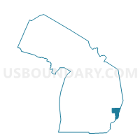
Outline

Summary
| Unique Area Identifier | 599420 |
| Name | Voting District 1476582000008 |
| County | St. Clair County |
| State | Michigan |
| Area (square miles) | 0.79 |
| Land Area (square miles) | 0.79 |
| Water Area (square miles) | 0.00 |
| % of Land Area | 100.00 |
| % of Water Area | 0.00 |
| Latitude of the Internal Point | 42.95867560 |
| Longtitude of the Internal Point | -82.43369500 |
Maps


Graphs
Select a template below for downloading or customizing gragh for Voting District 1476582000008, St. Clair County, Michigan


Neighbors
Neighoring Voting District (by Name) Neighboring Voting District on the Map
- Voting District 1476582000007, St. Clair County, MI
- Voting District 1476582000009, St. Clair County, MI
- Voting District 1476582000010, St. Clair County, MI
- Voting Districts not defined, St. Clair County, MI